


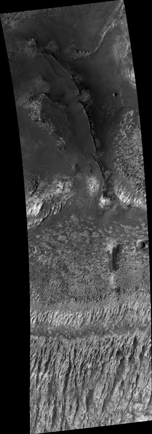
 PSP_001552_1410 shows gullies in a crater in Terra Sirenum in the southern hemisphere of Mars.
This image was acquired during the winter, which explains the abundant frost (the bright material) seen throughout the image. The frost is likely water frost, as opposed to carbon dioxide, because temperatures at this latitude probably do not get cold enough for carbon dioxide to condense.
The formation mechanism of gullies is much debated. Several theories support erosion by liquid water, while others favor dry debris flows or carbon dioxide. A major unknown is, if the gullies are formed by liquid water, does the water originate from the surface or subsurface? Dendritic structures, such as those seen in the alcove displayed in the subimage (approximately 1.3 km across; 2560 x 3000, 7MB), form from surface runoff on Earth. Water originating in the subsurface would not produce a structure like this. This alcove is evidence for a surface source for the water possibly required to form gullies.
Also interesting about this scene is the fact that the gullies occur at multiple elevations along the same crater wall. This is uncommon on Mars. Gullies, whether or not they are found in conjunction with an obvious horizontal layer, usually form at the same elevation on a given slope. It is unknown what caused these gullies to form at multiple elevations. Their locations are suggestive of a distributed water source, which also favors a surface, rather than a confined subsurface origin of water, such as an aquifer.
 Pits, Cracks, and Polygons in Western Utopia Planitia PSP_002202_2250 | Media credit: NASA/JPL/University of Arizona
 Utopia Planitia is part of the great northern lowlands of Mars, where there may have been an ancient ocean.
The pits, cracks, and polygons in Utopia have been interpreted as due to some combination of temperature variations in ice-rich ground, sublimation of ground ice, and collapse into subsurface voids.
This HiRISE image reveals many new details, including an abundance of boulders about 1 meter in diameter over the entire region. The infrared color of HiRISE reveals two types of materials: the brighter and yellowish areas are probably dusty and the darker and bluer areas are probably coarser particles--sand and rocks.

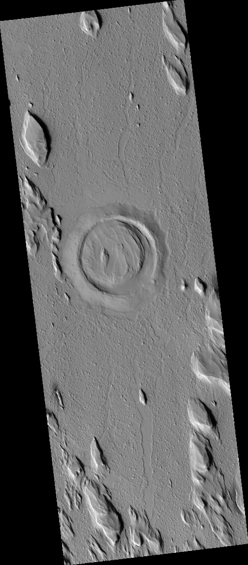
Bullseye Crater in Elysium Planitia PSP_003398_1910 | Media credit: NASA/JPL/University of Arizona
The pits, cracks, and polygons in Utopia have been interpreted as due to some combination of temperature variations in ice-rich ground, sublimation of ground ice, and collapse into subsurface voids.
This HiRISE image reveals many new details, including an abundance of boulders about 1 meter in diameter over the entire region. The infrared color of HiRISE reveals two types of materials: the brighter and yellowish areas are probably dusty and the darker and bluer areas are probably coarser particles--sand and rocks.
Bullseye Crater in Elysium Planitia PSP_003398_1910 | Media credit: NASA/JPL/University of Arizona
The sequence of events that formed this scene in the equatorial lowlands of Mars are as follows. First, a meteorite impact excavated the 2.2 kilometer (1.4 mile) diameter crater in the center of the picture. Second, the area was flooded by a vast lava flow. However, the lava was not able to overtop the rim of the crater and it remained a large depression.
Third, the area was blanketed by a series of layers of small particles carried by the wind. This deposit makes up what is called the Medusae Fossae Formation and may be composed of volcanic ash. Finally, the Medusae Fossae Formation was largely eroded away by the wind. However, the deposits within the crater were protected from the wind and have remained to this day.
The hills outside the crater are also remnants of the Medusae Fossae Formation.

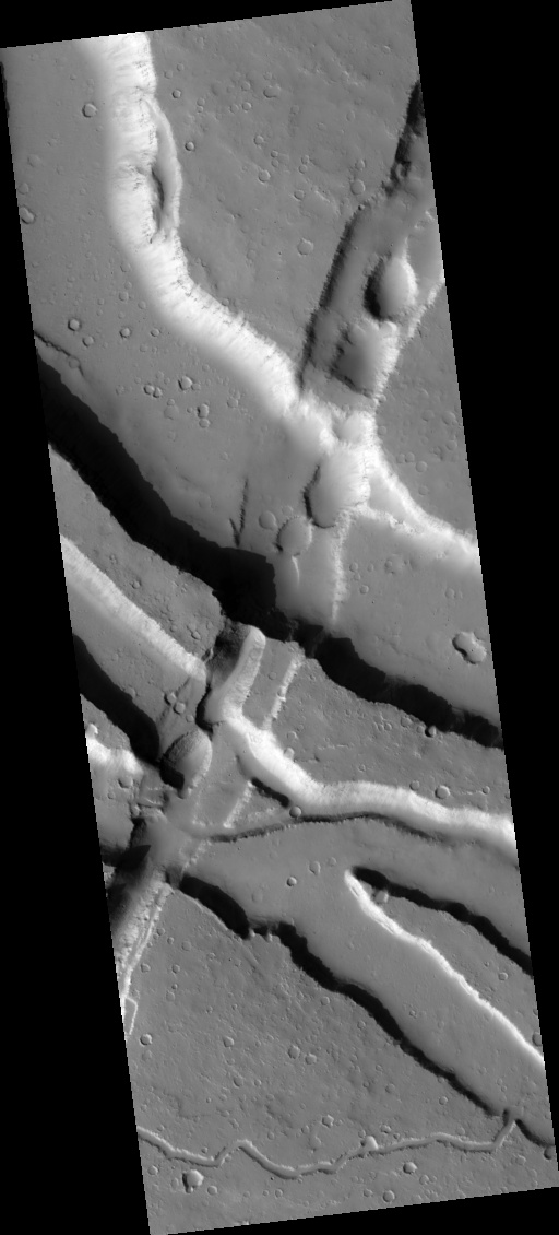
Faults and Channels on Elysium Mons PSP_003426_2035 | Media credit: NASA/JPL/University of Arizona
Third, the area was blanketed by a series of layers of small particles carried by the wind. This deposit makes up what is called the Medusae Fossae Formation and may be composed of volcanic ash. Finally, the Medusae Fossae Formation was largely eroded away by the wind. However, the deposits within the crater were protected from the wind and have remained to this day.
The hills outside the crater are also remnants of the Medusae Fossae Formation.
Faults and Channels on Elysium Mons PSP_003426_2035 | Media credit: NASA/JPL/University of Arizona
Elysium Mons is a large shield volcano on the opposite side of Mars from Olympus Mons and the other giant Tharsis volcanoes. Like its siblings in Tharsis, Elysium Mons is covered with lava flows.
The lower parts of Elysium Mons are also cut by large sinuous channels (or "rilles"). Features like these can be found on the Moon, where they were carved by lava. On Mars, there has been some suggestion that water, rather than lava, was responsible for the erosion.
This HiRISE image is covers a location where three different sinuous rilles (running generally west to east) come together and are then cut by a pair of faults (running roughly north-south). The ground has pulled apart and dropped down in between these two faults, forming a depression that geologists call a "graben."?? Where there was more focused ground collapse, small depressions (or "pit craters") formed. The thick coating of dust makes it hard to tell what fluid last ran through the sinuous rilles in this location. However, the layers of hard rock that can be occasionally seen poking through the dust indicate that what they eroded, was a stack of lava flows.

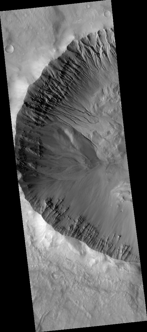
Spectacular Gullies Near Gorgonum Chaos PSP_003583_1425 | Media credit: NASA/JPL/University of Arizona
The lower parts of Elysium Mons are also cut by large sinuous channels (or "rilles"). Features like these can be found on the Moon, where they were carved by lava. On Mars, there has been some suggestion that water, rather than lava, was responsible for the erosion.
This HiRISE image is covers a location where three different sinuous rilles (running generally west to east) come together and are then cut by a pair of faults (running roughly north-south). The ground has pulled apart and dropped down in between these two faults, forming a depression that geologists call a "graben."?? Where there was more focused ground collapse, small depressions (or "pit craters") formed. The thick coating of dust makes it hard to tell what fluid last ran through the sinuous rilles in this location. However, the layers of hard rock that can be occasionally seen poking through the dust indicate that what they eroded, was a stack of lava flows.
Spectacular Gullies Near Gorgonum Chaos PSP_003583_1425 | Media credit: NASA/JPL/University of Arizona
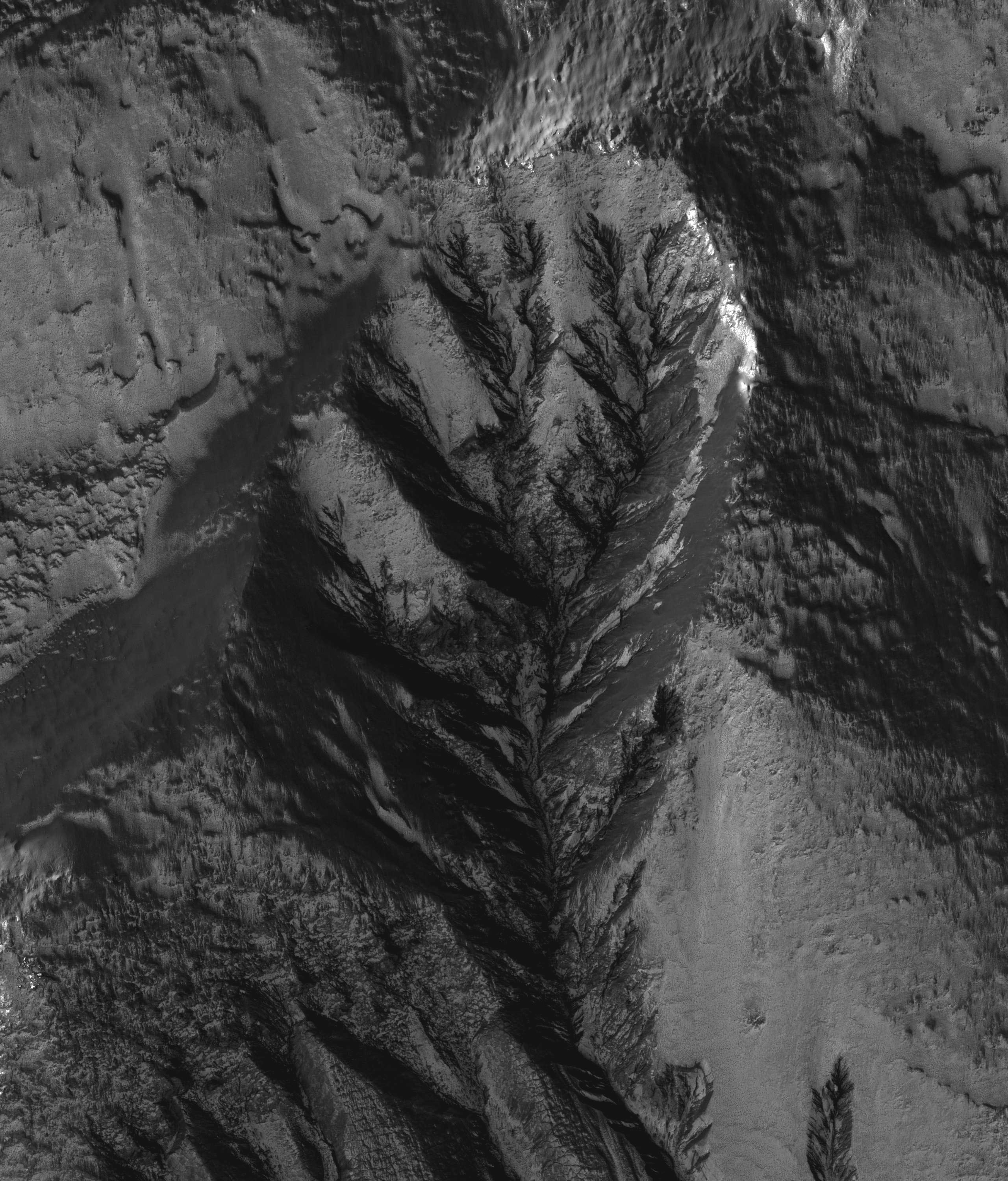
Of note is the variety of gully morphologies along the crater walls. The north and west walls have gullies, while the south wall has only landslides. "Mass wasting" is the more general term geologists use to describe landslides, slumps, and other movements of the ground in response to gravity. It usually occurs on steep slopes when the force of gravity causes weak or loose material to travel downslope. Mass wasting produces structures that are sometimes similar to gully channels, but which can usually be distinguished by their occurrence
on steep slopes.
The gullies on the north wall have eroded all the way to the crater rim. They appear older than other nearby gullies because they have existed long enough to be modified by permafrost processes as evidenced by the polgyonal fractures found on some of the channel and inter-gully walls. Another noticeable difference among the gullies is channel lengths. The gullies on the north wall and the group just to the left of these have much shorter channels than the gullies on the northwest wall. It is possible that the gullies with shorter channels had less fluid flow through their systems. The gullies appear to originate around a sequence of rocky layers near the crater rim.
Many of the gully channels appear to have boulders littered throughout . This is suggestive of a fluid flowing in these channels; a fluid would preferentially transport smaller particles and leave behind the larger ones, such as the boulders seen here. There are many overprinted small channels in each gully, as can be seen in the subimage. These are indicative of multiple flow events such that some channels experience flow, then are abandoned.
The subimage also shows several channels merging. Particularly interesting is the channel flowing from the top of the scene. There are several intertwining channels that merge into one just to the right of the center of the subimage. However, the way some channels truncate others suggests that there were at least three episodes of flow through this area.

Sample of the Olympus Mons PSP_003595_2115 | Media credit: NASA/JPL/University of Arizona
This image samples the rugged central portion of the mysterious "aureole" that extends to the west and north of Olympus Mons.
While many ideas for its formation have been advanced over the decades, these days it is generally thought to be a giant landslide deposit. The scene here fits that model with kilometer-scale (mile-sized) rocky hummocks and blocks strewn about. The blocks themselves are now covered with dust that is slumping off in small landslides or avalanches. These leave dark streaks on the sides of the blocks.

Landslides along the Walls of Bahram Vallis PSP_003605_2015 | Media credit: NASA/JPL/University of Arizona
Landslides are one of the most spectacular mass wasting features on Mars in terms of their areal extent and volume. Some of the best preserved landslides are in the Valles Marineris canyon system, but that's not the only place we see evidence for landslides.
This image of Bahram Vallis, a valley along the edges of the circum-Chyrse Basin, has large mounds of material at the base of the valley floor. These deposits of material are different from those deposits seen at Valles Marineris. They do not have a "ribbed" surface of transverse ridges. They also do not have a semi-circular distal margin giving it a lobate appearance and they have not travelled for many kilometers away from their source region like most Valles Marineris landslides do.
These particular deposits have the characteristic shape of rotational landslides or slumps on Earth where material along the entire wall slumps down and piles debris at the base of the slope, much like a person who slumps down the back of a chair. Right at the cliff edge at the top of the slope, the shape of the area where the valley wall gave way to a landslide is not straight, but rather curved or semi-circular. This is typical of large landslides where the failure area has an arcuate "crown" shape. The fact that landslides have occurred here indicates that the valley walls are not stable and the materials respond to Martian gravity with mass movements.
Scientists studying landslides can use these images along with topographic data to model how the wall failed, which can give clues to the nature of the materials (type, strength, etc.) in this region. Another consequence of landslide activity in Bahram Vallis is that the overall width of the valley will increase over time.

Strengths of Materials in Ganges Mensa PSP_003618_1725 | Media credit: NASA/JPL/University of Arizona
The amount of time that a geologic deposit is exposed at the surface can be measured by counting the number of impact craters that is contains in a given area. The longer a deposit is exposed at the surface the more impact events that it endures.
In this image, there are at least two distinct geologic units, a light–toned bedrock and a surface veneer of dark–toned material that contains sand dunes. The light–toned bedrock must be older that the dark–toned veneer of sand; the bedrock must have been present first in order to be covered by the sand. The dark–toned sand however, contains many more impact craters than the light–toned bedrock. This suggests that the surface of the bedrock is younger than the veneer of sand.
This can be explained by the bedrock being more easily eroded by the wind than the veneer of sand. The surface of the bedrock is rapidly refreshed (craters smoothed away), while the sand veneer retains impact craters for a longer period of time. This indicates that the bedrock is very friable (weak and easily eroded, in this case by the wind) and the sand veneer is less friable.

Lots of Layering in Becquerel Crater PSP_003656_2015 | Media credit: NASA/JPL/University of Arizona
Becquerel Crater is one of several impact craters in Arabia Terra that have light-toned layered deposits along the crater floor. The light-toned deposits are particularly striking to look at in this HiRISE image because they are stacked together to produce a thick sequence of layered beds. The layers appear to be only a few meters thick and show little variations in thickness.
On Earth, layered beds with these characteristics are typically formed in water environments, although aeolian (wind blown) deposition on Mars through a cyclic process is also possible. Volcanic eruptions would not be expected to produce ash or volcanic flows of such regular thickness, and there are no nearby volcanic vents.
Some of the layering in the image appears dark, probably due to deposition of basalt sand along flatter surfaces rather than any compositional variations in the layer beds themselves. Faults can also be seen displacing portions of the layered beds. The surface of the light-toned deposit is not smooth but instead appears disrupted into polygonal cracks and blocks.
Relative to most surfaces on Mars, there are almost no impact craters seen in this image. This is not due to a young age but rather to the friable (easily eroded) nature of the light-toned layered deposits that enable wind easily to erode the unit, thereby removing any impact craters. Evidence of erosion by the wind is most apparent in the bottom of the image where linear ridges most likely formed by wind scouring away material in a north-south direction and creating the ridges.

Flow Obstructions and Wakes Southeast of Elysium PSP_003663_1775 | Media credit: NASA/JPL/University of Arizona
HiRISE image PSP_003663_1775 covers a portion of the Martian equatorial plains called Elysium Planitia. In this location, lava that was once flowing across the surface interacted with multiple obstructions.
The image is near the southern margin of where these flows occurred, and it is likely that the obstructions are small hills in the underlying surface that poked up through the flow. As the flowing material moved past the obstructions, piles of rocky debris banked up on the northwestern or upstream sides while long trails or "wakes" were left on the southeastern or downstream side. Changes in the direction of the "wakes" indicate that the direction of flow altered somewhat over time, and fractures across the surface show the top of the flow was carried along as a brittle "skin."
The rough and blocky nature of the material where it piles along obstructions and other attributes suggest the flowing material was lava and was part of a much larger and relatively young (by geologic standards) flow that occurred in this part of Mars.

Channel on the Southern Flanks of Ascraeus Mons PSP_003686_1865 | Media credit: NASA/JPL/University of Arizona
Ascraeus Mons is the northernmost of the three giant Tharsis Montes volcanoes, with large channels carved into the lower parts of its flanks.
There has been a long-standing debate whether these were eroded by flowing water or lava. The section seen in this HiRISE images favors the lava hypothesis, since the shapes of the "islands" in the channel are not as streamlined as would be expected from water erosion. Instead, they have the same shape as was seen in lava channels on the Earth, such as the early phases of the ongoing eruption of Kilauea volcano or the 1984 eruption of Mauna Loa volcano (both in Hawaii).
The very sharp bend in the channel is also uncommon for water carved channels and suggests that the erosion was taking advantage of weaknesses in the volcano caused by faults and fractures. Unfortunately, we cannot tell for sure what the fluid was because of the thick coating of dust. HiRISE reveals the intricate sculpting of this dust as the wind predominantly blows from northwest to southeast. However, in the channel, the wind generally runs down the channel, sometimes even going perpendicular to the wind outside it.

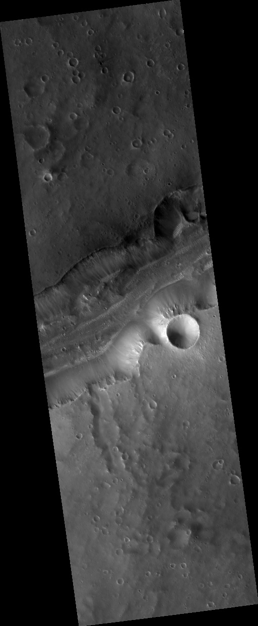
Where Water Once Flowed Over the Rim of Holden Crater PSP_003710_1530 | Media credit: NASA/JPL/University of Arizona
The formation of the approximately 150 km diameter Holden Crater interrupted the northward flowing Uzboi Vallis channel system. Relief associated with the rim of Holden effectively blocked the channel.
HiRISE image PSP_003710_1530 covers the portion of Holden Crater's rim where it was overtopped by water that had backed up in Uzboi Vallis to the south. Water flowing over the rim in multiple locations eventually focused on a single channel that then cut deeply into the rim. After the impounded water drained into the crater, the steep wall on the east side of the main channel collapsed in a landslide that remains visible along the floor. Several outcroppings of variably bright material are visible in the scar produced by the slide.
More reading .......
on steep slopes.
The gullies on the north wall have eroded all the way to the crater rim. They appear older than other nearby gullies because they have existed long enough to be modified by permafrost processes as evidenced by the polgyonal fractures found on some of the channel and inter-gully walls. Another noticeable difference among the gullies is channel lengths. The gullies on the north wall and the group just to the left of these have much shorter channels than the gullies on the northwest wall. It is possible that the gullies with shorter channels had less fluid flow through their systems. The gullies appear to originate around a sequence of rocky layers near the crater rim.
Many of the gully channels appear to have boulders littered throughout . This is suggestive of a fluid flowing in these channels; a fluid would preferentially transport smaller particles and leave behind the larger ones, such as the boulders seen here. There are many overprinted small channels in each gully, as can be seen in the subimage. These are indicative of multiple flow events such that some channels experience flow, then are abandoned.
The subimage also shows several channels merging. Particularly interesting is the channel flowing from the top of the scene. There are several intertwining channels that merge into one just to the right of the center of the subimage. However, the way some channels truncate others suggests that there were at least three episodes of flow through this area.

Sample of the Olympus Mons PSP_003595_2115 | Media credit: NASA/JPL/University of Arizona
This image samples the rugged central portion of the mysterious "aureole" that extends to the west and north of Olympus Mons.
While many ideas for its formation have been advanced over the decades, these days it is generally thought to be a giant landslide deposit. The scene here fits that model with kilometer-scale (mile-sized) rocky hummocks and blocks strewn about. The blocks themselves are now covered with dust that is slumping off in small landslides or avalanches. These leave dark streaks on the sides of the blocks.
Landslides along the Walls of Bahram Vallis PSP_003605_2015 | Media credit: NASA/JPL/University of Arizona
Landslides are one of the most spectacular mass wasting features on Mars in terms of their areal extent and volume. Some of the best preserved landslides are in the Valles Marineris canyon system, but that's not the only place we see evidence for landslides.
This image of Bahram Vallis, a valley along the edges of the circum-Chyrse Basin, has large mounds of material at the base of the valley floor. These deposits of material are different from those deposits seen at Valles Marineris. They do not have a "ribbed" surface of transverse ridges. They also do not have a semi-circular distal margin giving it a lobate appearance and they have not travelled for many kilometers away from their source region like most Valles Marineris landslides do.
These particular deposits have the characteristic shape of rotational landslides or slumps on Earth where material along the entire wall slumps down and piles debris at the base of the slope, much like a person who slumps down the back of a chair. Right at the cliff edge at the top of the slope, the shape of the area where the valley wall gave way to a landslide is not straight, but rather curved or semi-circular. This is typical of large landslides where the failure area has an arcuate "crown" shape. The fact that landslides have occurred here indicates that the valley walls are not stable and the materials respond to Martian gravity with mass movements.
Scientists studying landslides can use these images along with topographic data to model how the wall failed, which can give clues to the nature of the materials (type, strength, etc.) in this region. Another consequence of landslide activity in Bahram Vallis is that the overall width of the valley will increase over time.
Strengths of Materials in Ganges Mensa PSP_003618_1725 | Media credit: NASA/JPL/University of Arizona
The amount of time that a geologic deposit is exposed at the surface can be measured by counting the number of impact craters that is contains in a given area. The longer a deposit is exposed at the surface the more impact events that it endures.
In this image, there are at least two distinct geologic units, a light–toned bedrock and a surface veneer of dark–toned material that contains sand dunes. The light–toned bedrock must be older that the dark–toned veneer of sand; the bedrock must have been present first in order to be covered by the sand. The dark–toned sand however, contains many more impact craters than the light–toned bedrock. This suggests that the surface of the bedrock is younger than the veneer of sand.
This can be explained by the bedrock being more easily eroded by the wind than the veneer of sand. The surface of the bedrock is rapidly refreshed (craters smoothed away), while the sand veneer retains impact craters for a longer period of time. This indicates that the bedrock is very friable (weak and easily eroded, in this case by the wind) and the sand veneer is less friable.
Lots of Layering in Becquerel Crater PSP_003656_2015 | Media credit: NASA/JPL/University of Arizona
Becquerel Crater is one of several impact craters in Arabia Terra that have light-toned layered deposits along the crater floor. The light-toned deposits are particularly striking to look at in this HiRISE image because they are stacked together to produce a thick sequence of layered beds. The layers appear to be only a few meters thick and show little variations in thickness.
On Earth, layered beds with these characteristics are typically formed in water environments, although aeolian (wind blown) deposition on Mars through a cyclic process is also possible. Volcanic eruptions would not be expected to produce ash or volcanic flows of such regular thickness, and there are no nearby volcanic vents.
Some of the layering in the image appears dark, probably due to deposition of basalt sand along flatter surfaces rather than any compositional variations in the layer beds themselves. Faults can also be seen displacing portions of the layered beds. The surface of the light-toned deposit is not smooth but instead appears disrupted into polygonal cracks and blocks.
Relative to most surfaces on Mars, there are almost no impact craters seen in this image. This is not due to a young age but rather to the friable (easily eroded) nature of the light-toned layered deposits that enable wind easily to erode the unit, thereby removing any impact craters. Evidence of erosion by the wind is most apparent in the bottom of the image where linear ridges most likely formed by wind scouring away material in a north-south direction and creating the ridges.

Flow Obstructions and Wakes Southeast of Elysium PSP_003663_1775 | Media credit: NASA/JPL/University of Arizona
HiRISE image PSP_003663_1775 covers a portion of the Martian equatorial plains called Elysium Planitia. In this location, lava that was once flowing across the surface interacted with multiple obstructions.
The image is near the southern margin of where these flows occurred, and it is likely that the obstructions are small hills in the underlying surface that poked up through the flow. As the flowing material moved past the obstructions, piles of rocky debris banked up on the northwestern or upstream sides while long trails or "wakes" were left on the southeastern or downstream side. Changes in the direction of the "wakes" indicate that the direction of flow altered somewhat over time, and fractures across the surface show the top of the flow was carried along as a brittle "skin."
The rough and blocky nature of the material where it piles along obstructions and other attributes suggest the flowing material was lava and was part of a much larger and relatively young (by geologic standards) flow that occurred in this part of Mars.

Channel on the Southern Flanks of Ascraeus Mons PSP_003686_1865 | Media credit: NASA/JPL/University of Arizona
Ascraeus Mons is the northernmost of the three giant Tharsis Montes volcanoes, with large channels carved into the lower parts of its flanks.
There has been a long-standing debate whether these were eroded by flowing water or lava. The section seen in this HiRISE images favors the lava hypothesis, since the shapes of the "islands" in the channel are not as streamlined as would be expected from water erosion. Instead, they have the same shape as was seen in lava channels on the Earth, such as the early phases of the ongoing eruption of Kilauea volcano or the 1984 eruption of Mauna Loa volcano (both in Hawaii).
The very sharp bend in the channel is also uncommon for water carved channels and suggests that the erosion was taking advantage of weaknesses in the volcano caused by faults and fractures. Unfortunately, we cannot tell for sure what the fluid was because of the thick coating of dust. HiRISE reveals the intricate sculpting of this dust as the wind predominantly blows from northwest to southeast. However, in the channel, the wind generally runs down the channel, sometimes even going perpendicular to the wind outside it.
Where Water Once Flowed Over the Rim of Holden Crater PSP_003710_1530 | Media credit: NASA/JPL/University of Arizona
The formation of the approximately 150 km diameter Holden Crater interrupted the northward flowing Uzboi Vallis channel system. Relief associated with the rim of Holden effectively blocked the channel.
HiRISE image PSP_003710_1530 covers the portion of Holden Crater's rim where it was overtopped by water that had backed up in Uzboi Vallis to the south. Water flowing over the rim in multiple locations eventually focused on a single channel that then cut deeply into the rim. After the impounded water drained into the crater, the steep wall on the east side of the main channel collapsed in a landslide that remains visible along the floor. Several outcroppings of variably bright material are visible in the scar produced by the slide.
More reading .......


0 comments:
Post a Comment